|
von Ewald Diaries: Maps of the |
 |
|
|
|
von Ewald Diaries: Maps of the |
|
|
|
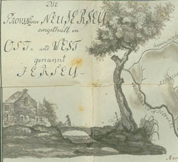
Captain Johann von Ewald (1744-1813), was a Hessian officer who came to America in 1776 with the British military forces. Von Ewald was a participant in many of the significant battles of the war, and was with Lord Cornwallis at the surrender of Yorktown in 1781. He kept a diary of his experiences throughout the Revolutionary War, but just as importantly created numerous maps of the areas he was in, with the placement of troops and fortifications. The diary was acquired following World War II by a Bloomsburg native, Major Joseph P. Tustin, a historian for the United States Air Forces in Europe who came across it in his travels. He spent 30 years translating the work and verifying facts, and it was published in 1979 by Yale University Press under the title Diary of the American War: A Hessian Journal.
The published work included 33 of the original color maps from the four volumes of the diary, but they were reproduced in black and white. Three of the maps were also too large in scale and so were redrawn to fit on the printed page. Presented here for the first time are the original color maps of Johann von Ewald, in their full richness and detail. This site includes the 29 maps used in the published book from Volumes 1, 2, and 4 of the diary. Tustin was at first unable to locate the original of Volume 3, until finally finding an 1831 copy at the Schloss Glücksburg library in the possession of the Prince of Scheswig-Holstein-Glücksburg. Photographic copies of these maps were made and used in the translated work, but not being the original maps are not included here.
 |
To the Finding Aid for the Joseph P. Tustin Papers
Back to Special Collections Page
Updated 11/12/08