
Introduction to Government Documents
for Geography
Prepared by Kathryn Yelinek

|
Bloomsburg University of
Pennsylvania |
|
|
Introduction to Government Documents for Geography Prepared by Kathryn Yelinek |
|
1. Print Reference Sources
For anything from basic to more in-depth research, these print resources will get you started.
For help in reading a Sudocs (that is, a Government Documents) call number, go to Reading SuDocs Call Numbers.
|
ITEM |
ITEM LOCATION |
CALL NO. |
|
US Geological Survey Topographic Maps |
Map Collection, 2nd floor |
I 19.81: |
|
Public Land Statistics (annual) |
Government Documents Collection |
I 53.1/2:[yr] |
|
Minerals Yearbook (annual) |
Government Documents Collection |
I 19.165: [yr] |
|
USGS Fact Sheets (covers wide variety of topics) |
Government Documents Collection |
I 19.127: |
|
Index, National Park Service (annual) |
Government Documents Collection |
I 19.103: [yr] |
|
Pennsylvania Geological Survey |
Pennsylvania Documents Collection |
PA Doc PYG 345/4.21/8 |
|
The Geology of Pennsylvania |
Pennsylvania Documents Collection |
PA PYG 345.2:G 345P 1999 |
|
Using Government Information Sources: Electronic and Print |
Reference Collection |
Z1223.Z7 S4 2001 |
PILOT Searching
The above and below resources are examples of the type of government information available. There's a lot more out there!!
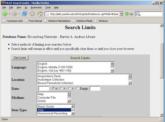
When looking for government information in PILOT, you will want to limit your search by library location. This type of search will allow you to bring back ONLY government documents.
To limit your searches, click on SET MORE LIMITS:
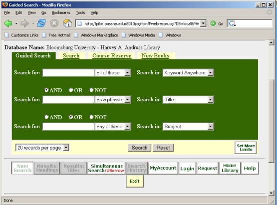
Highlight the different Pennsylvania Government Collections choices and U.S. Government Documents Collections choices (hold down the CONTROL key while you do this). Then click SET LIMITS.
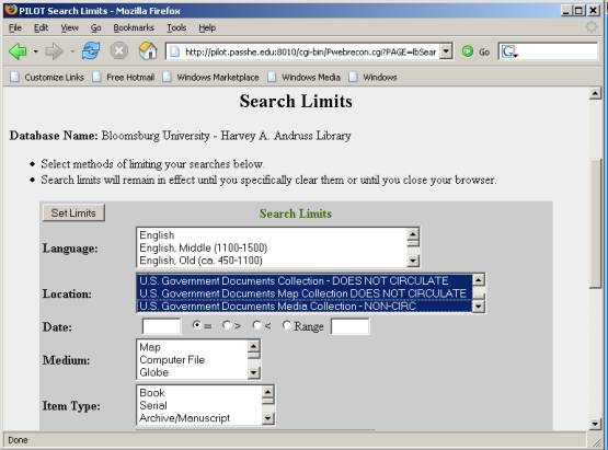
If you are looking specifically for maps, limit by item type.
2. Electronic Reference
Resources
More and more government information
is being made available electronically. Just like the print resources, these
documents will help you with everything from basic to in-depth research.
Most are available through PILOT; others you can find directly through the
following links.
|
Item |
URL |
|
Endangered Species Bulletin (newsletter) |
http://endangered.fws.gov/bulletin.html |
|
Water Resources Data for Pennsylvania |
http://pa.water.usgs.gov/ar/index.html |
|
Mineral Industry of Pennsylvania |
http://purl.access.gpo.gov/GPO/LPS50449 |
|
Water Logs (newsletter) |
http://nwql.usgs.gov/Public/news/news.html |
| Natural Resource Year in Review | http://www2.nature.nps.gov/YearinReview/ |
| Volcano Watch (newsletter) | http://hvo.wr.usgs.gov/volcanowatch/ |
|
New Publications of the Geological Survey |
http://pubs.usgs.gov/publications/index.html |
3. Databases for research
These databases are maintained by government agencies. They are accessible from the government web sites or directly from the following links.
Database name |
Government Agency Responsible |
Description with URL |
| Geographic Names Information System | US Geological Survey, in partnership with the US Board on Geographic Names | Contains information for almost 2 million physical and cultural geographic features in the United States and its territories. |
| Envirofacts | Environmental Protection Agency | Contains information having to do with environmental issues. |
|
Dataweb |
Bureau of Reclamation |
Contains information on dams, reservoirs, and power plants. |
|
Agrimet |
Bureau of Reclamation |
Contains agricultural and meteorological information relating to water use. |
|
Hydromet |
Bureau of Reclamation |
Contains meteorological information to provide streamflow forecasting and current runoff conditions for river and reservoir operations. |
4. Internet Sites
As I mentioned above, more and more government information is located on-line. The following sites will lead you to more information.
|
Name of Site |
Description and URL |
| Department of the Interior | The Department of the Interior oversees public lands, natural resources, and Indian affairs. Use this site as a portal to its many bureaus and offices. |
| United States Geological Survey | The USGS acts as an independent fact-finding agency for issues relating to natural resource conditions, issues, and problems. This is the agency that issues topo maps, monitors earthquake and volcano activity, and more. |
| Bureau of Reclamation | This bureau of the Department of the Interior manages, develops, and protects water resources in the US. Use their Dataweb, Agrimet, and Hydromet databases (see above) for statistics relating to water, dams, and reservoirs. |
| Minerals Management Service | This bureau of the Department of the Interior oversees development of the offshore oil and gas industry in Alaska, the Pacific, and the Gulf of Mexico. |
| Office of Surface Mining | This bureau of the Department of the Interior oversees coal mining. Search the site for information relating to coal mining and the reclamation of abandoned mines. |
| Energy Information Administration | This agency collects and makes public data on coal, petroleum, natural gas, electric, and nuclear energy. The site includes some basic information on issues relating to energy, but you would use it mostly for hard numbers, forecasts, and statistics. |
| TerraServer USA | Not strictly a government site, this site allows you to generate aerial and topographic images for any address in the US. |
| Environmental Protection Agency | The Environmental Protection Agency works to develop and enforce regulations that implement environmental laws enacted by Congress. |
| National Oceanic and Atmospheric Administration | NOAA oversees scientific research having to do with weather, climate, fisheries, and the ocean. |
| National Atlas of the United States | This site allows you to custom make maps of the US. |
| TopoZone | Not technically a government site, the makers of TopoZone worked with the USGS to make interactive topographic maps available on the web. |
| Online Soil Surveys | From the US Department of Agriculture, this site provides soil survey information online from all 50 states. |
| Pennsylvania Department of Conservation and Natural Resources | The DCNR is responsible for maintaining Pennsylvania's state parks, state forests, and other natural resources. |
If you have any other questions, please stop by the Government Documents Office (Andruss Library 235) or call 389-4228 for assistance. You may also contact me for help.
| Kathryn Yelinek |
| Coordinator of Government Documents |
| Andruss Library 235 |
| kyelinek@bloomu.edu |
| 389-4228 |
Last updated: February 15, 2005