|
|
16/20/22
|
|
|
16/20/22
|
Box 1:
Bridges
B1- Kramer Bridge, South of Rohrsburg, 1960
B2- Fowlersville Covered Bridge, West branch of Briar creek, 1955
B3- Stillwater Covered Bridge, Especially preserved by action of the county as a memorial to our covered bridge, 1960
B4- "Jud Christie Wood" covered bridge over Little Fishing Creek, 1960
B5- Krickbaum Bridge near Bear Gap, 1960
B6- Wanich Bridge over Little Fishing Creek, 1960
B7- Former Buckhorn Bridge over Hemlock Creek, 1940
B8- Wagner Bridge over North Branch Roaring Creek, 1960
B9- Laubach or Well Hess Bridge, near Grassmere, 1960
B10- Former Buckalew Bridge over Pine Creek, 1963
B11- Hanging Bridge to Fleckenstine's Island, Columbia County, PA (Backdrop: Huntington Mountain)
B12- Former Stauffer Bridge over Little Fishing Creek, 1960
B13- Former Hemlock Bridge, near Buckhorn, 1940
B14- In removing the same Eckman Bridge over Little Fishing Creek, its basic structure was revealed, 1975
Buildings
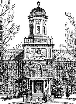
Bld1- Carver Hall, Bloomsburg State College, 1940
Bld2- Roaring Creek Valley Friends Meeting House, South of Numidia, built 1814, 1960
Bld3- St. Paul's Episcopal Church, Bloomsburg, 1930
Bld4- Red Mill, near Buckhorn, 1970
Bld5- Former Eli Barton House, constructed 1840: A number of renovations were added at various times, 1965
Bld6- Interior Quaker Meeting House, identified as Catawissa Friends Meeting House, 1940
Bld7- St. Paul's Episcopal Church, Bloomsburg, 1928
Streams
S1- View from Catawissa Overlook, north through the Catawissa Narrows, 1960
S2- North branch of the Susquehanna River, turning south to enter the Catawissa Narrows, 1964
S3- Knob Mountain Reflected in Fishing Creek, 1960
S4- Confluence of Fishing Creek with the north branch of the Susquehanna River, a well-known landmark for the Indian and early Colonial traveler, 1950
S5- Rickett's Glen Falls, Luzerne County, PA, 1950
S6- Cozy Nook, near Jonestown, Columbia County, PA, 1965
S7- Ruins of Rupert Canal Aqueduct, 1940
S8- Winding rapids of Roaring Creek in its lower course, 1955
S9- Roaring Creek Rapids approaching the gorge, 1960
Box 2:
Mountains
M1- Mainville Gap, 1960
M2- Knob Mountain near Orangeville, PA, taken from the southwest, 1940
M3- Orangeville, at the front of Knob Mountain, 1940
M4- Knob Mountain taken from the west, 1970
M5- Western spur of Catawissa Mountain, viewed from the northwest, 1972
M6- Knob Mountain from the southwest, 1940
M7- McCauley Mountain (Summer), 1960
M8- McCauley Mountain (winter), 1960
M9- North Mountain, winter scene, 1970
Landscape
L1- Fishing Creek Valley, north from the Cemetery Cliff, 1940
L2- looking east across the hills of Montour County to Catawissa Mountain, 1960
L3- this railroad bridge, now abandoned, is located at the original Ford and Ferry site for the region's river crossing, 1970
L4- Main Township landscape with square field pattern, 1972
L5- Rolling Farm landscape with square field pattern, identified as Franklin Township, Southern Columbia County, 1970
L6- View from the hill south through Catawissa Narrows and beyond, 1975
L7- Knob Mountain, Orangeville, PA, viewed from the southwest, 1940
L8- Village of Rupert with the Catawissa Narrows and Catawissa Mountain in the background, 1972
L9- Up the Catawissa Creek Valley to Mainville, 1965
L10- Coles Creek Vista north to North Mountain, 1960
Farm Scenes
F1- The "Corn was in Shock" in Cleveland Township, Columbia County, 1960
F2- Plowing scene near Bloomsburg, 1930
Trees
T1- Lordly pines make a turn in the road north of Benton, 1970
T2- Rickett's Glen Path, 1965
T3- One-time belfry for St. Gabriel's Church, Coles Creek, Columbia County, PA, 1925
T4- "Once in a Lifetime"- spectator leaving the Catawissa Overlook, 1960
Updated 2/15/11