|
|
|
|
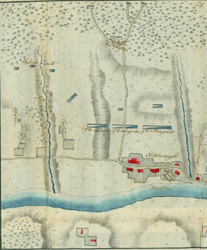
The left half of the map.
|
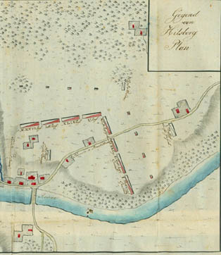
The right half of the map.
|
Plan of the area of Hillsborough
Click on a section of the map for a larger view.
|
|
|
|
The left half of the map.
|
The right half of the map.
|
The plan is believed to be the only contemporary map extant showing a part of General Howe's unsuccessful maneuver to lure Washington out of his strong positions into open warfare. One June 13, 1777, Howe and Cornwallis left New Brunswick and marched to the Millstone River. This plan shows the 1st Division of the British army, under Cornwallis, deployed on the high ground around the village of Hillsborough. At the lower middle part of the plan is Schenck's Bridge, by which the British crossed to Hillsborough. Captain Ewald's company is shown to the left of the three Hessian grenadier battalions. At the fork of the road above is the 2d Battalion of Light Infantry, with its outposts beyond. Eight British regiments are faced in the direction of Washington's army along the "Chemin à Boundbrook" ("road to Bound Brook"). At the right are Captain Wreden's jägers and the 1st battalion of Light Infantry. In and near the village are the 16th Regiment of Light Dragoons and the quarters of Colonel von Donop and Lord Cornwallis.