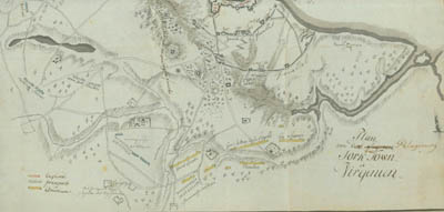
Plan of the Siege of York Town in Virginia
Click on a section of the map for a larger view.
Ewald's plan appears to be based on a plan of the
same title published in London on March 1, 1787 and used by Tarleton in his History
of the Campaigns of 1780 and 1781. Ewald, however, extended his plan
into Gloucester County and added his own remarks.
At bottom right on the
Yorktown side are shown the headquarters of Washington and Rochambeau and the
American artillery. Above and to the left are French artillery, General
Lincoln, General le Marquis de la Fayette, General Siwoens (Steuben), and
Clinton. To the left are the French regiments Saintonge, Soissen[nais],
Deux-Ponts, and Bourbon[nais]. The remark at the center reads:
"British redoubts occupied by the French." At the top are shown
the first and second parallels, "Moors" [Moore's] House, and American
and French batteries. At lower left are the French regiments Agénais, Gatinais, Touraine; the Volunteers of Saint-Simon; and a French battery.
Below Yorktown is the Fusiliers' Redoubt, "Which during the entire siege
was maintained." Also shown are the numbered regiments in Yorktown
itself and the sunken ships Guadeloupe and Charon in the York
River.
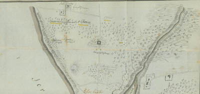
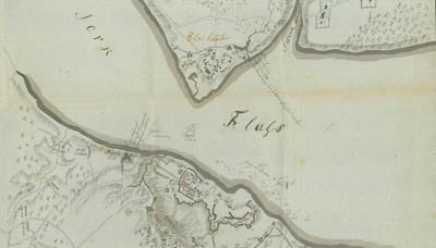
On the Gloucester side,
numbered redoubts are visible in the town itself: No. 1, Rangers; No. 2, Legion;
No.3, 80th Regiment; No. 4, unassigned. At the mouth of Sarah Creek Ewald
noted, "Place where I stood when French fleet arrived before the mouth of
the York River." The area above the town is labeled "Mostly
cut-down woods." In front of the work on the road leading out of
Gloucester are stationed French sentries. Toward the bottom are
"Infantry picket," "Cavalry picket," "Corps under
General Choisy," and "Hussars." At the left of the plan is
"Sauls" [Seawell's] Plantation. The headquarters are shown at
Seawell's Ordinary.
Back to Map List