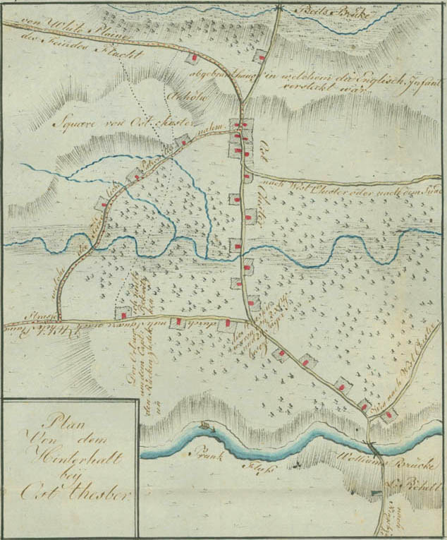
Plan of the Ambuscade at East Chester
[October 3, 1779]
The plan shows the old village of East Chester, traversed by the Hutchinson River, which was located beyond Third Avenue in present Mount Vernon. The ambuscade is indicated above the village by a "burnt-out house in which the English infantry was hidden," between Pell's Bridge and the fork of the roads to White Plains and New Rochelle. Ewald occupied a hill at the lower left of the plan where the horizontal writing states, "The place where I stopped to protect Captain Beckwith's rear." At the fork of the roads to the right, "The roads were occupied by 2 noncommissioned officers and 24 jägers." At the bottom of the plan, across the Williams Bridge and the Bronx River, a jäger picket was posted under Lieutenant Bickell. The British ambuscade failed because the Americans approached East Chester from an unexpected direction along the dotted "Road which the enemy patrol took" and escaped by the road to White Plains, marked "Flight of the enemy." Ewald's support is indicated by the dotted lines running across the terrain and the East Chester heights to the White Plains road.