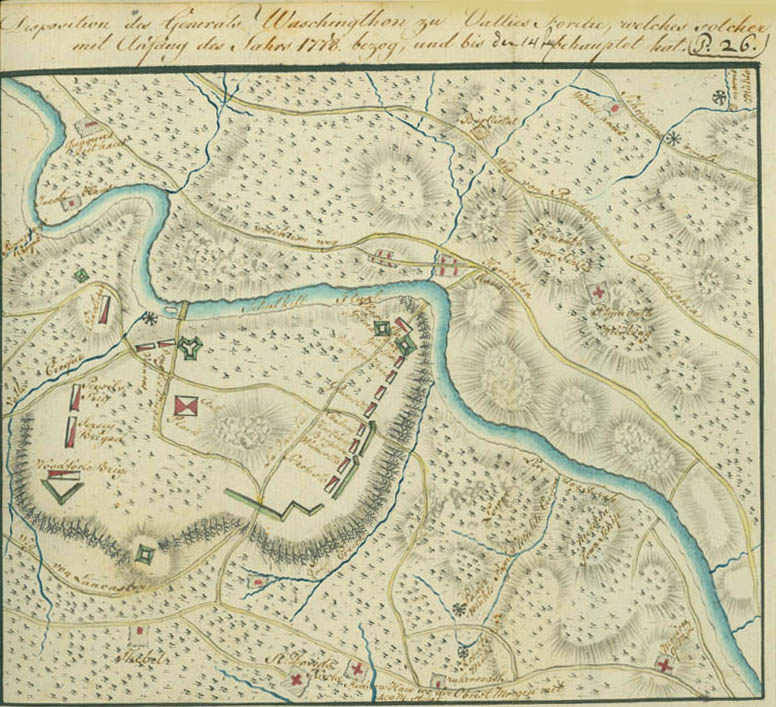
Disposition of General Washington at Valley Forge, Which He Occupied at the Beginning of the Year1778, and Has Maintained Until the 14th of June
This plan is one of only three extant contemporary maps of the encampment, and probably represents a composite of information from reports of spies, deserters, prisoners, and reconnaissance. The troop dispositions, with the spellings corrected, read as follows, beginning at left corner of the plan: Carolina (McIntosh's North Carolina Brigade), on the hill across Valley Creek; Douglas (McDougall) Brigade (actually Sullivan's Connecticut Brigade) and Varnum's (Rhode Island Brigade), below the bridge across the Schuylkill River, with artillery park below. To the right of Valley Creek, Pennsylvania Brigade (Conway's), Jersey Brigade (Maxwell's New Jersey Brigade), and Woodford's (Virginia) Brigade. In center, at the bend of the river, descending: Pennsylvania grenadiers (Muhlenberg's Pennsylvania-Virginia Brigade), General Greene; Patterson's (Maine, Massachusetts, and Vermont) Brigade; unnamed brigade; Glover's (Massachusetts) Brigade; Conway's Brigade (misplaced); Huntington's (Connecticut) Brigade; Scott's (Virginia) Brigade. Across the road, Lafayette's headquarters. Missing are Weedon's Virginia Brigade, Learned's Massachusetts Brigade, Poor's New Jersey and New York Brigade and Washington's headquarters. The roads above the Schuylkill River are the Skippack road, road from Reading to Philadelphia and Wissahickon road. The note at the bottom of the map reads: "Radnor's house, where Colonel Morgan and 400 men are stationed."